
Data for indicators of cities’ economic and financial health
Location risk metrics for COVID-19 economic recovery
Mobility data analytics is becoming very important to inform cities' understanding and response to the impacts of COVID-19 restrictions. Among suggested measures is a time master planning solution – shaping social distancing policies through spatiotemporal zoning and monitoring. That involves a set of big data-linked metrics on the urban physical environment, business diversity, and mobility developed by Habidatum. These metrics are accessible via a spatiotemporal interface, cover American, European, and Asian cities, and can be quickly expanded globally.
With this project, Habidatum was honored to be included in Fast Company’s World Changing Ideas list in the nomination Spaces, Places, and Cities. The annual list is seeking to elevate products and concepts that make the world a better place – cities and living in them cleaner, more efficient, more beautiful, and more equitable for their citizens.
How is this work transformative?
Firstly, mobility and spend data is turned into indicators of economic and financial health, which support actionable insights through big data-linked KPIs for city managers, retailers, or financial institutions.
Habidatum works closely with city authorities to train them to use the analytical metrics for timely responses to the impacts of COVID-19 related restrictions. The multiple applications of the metrics include:
- site-specific local economy/SME support programs,
- road-mapping pedestrian and bike infrastructure development,
- time zoning regulations for reopening public spaces and commercial venues,
- commercial real estate portfolio management – e.g. re-profiling, and sale/lease decisions in the view of changing consumer demand, the turn to work-at (or near)-home, e-commerce consumption with reduced offline retail visits, etc.
Secondly, ensuring privacy-protected use of data. Data from various sources is aggregated using Chronotope Grid, a privacy-by-design data standard, which counts activity in spatiotemporal cells, i.e. shows the aggregated volume of activity at a given time in a given location without an option to track it back to individual records.
This is especially important in view of increased privacy concerns related to big data applications for COVID-19 studies. The infrastructure provides a guarantee of ethical and privacy-protected data use, allowing at the same time for a high granularity of insights, data quality checks, and security audits. The delivered metrics are aggregated but granular, cleaned and validated, and transparent in terms of methodology and composition methods.
Thirdly, providing an easy way to navigate in the complex and unstructured mobility data milieu, such as GPS app usage, online maps, or merchants. Location risk metrics are in a tabular format suitable for integration into real estate and retail business financial models, into GIS applications used by urban analysts and planners, and into an interactive dashboard for monitoring and status checks.
Habidatum’s UI components are modular and ready for multiple configurations: one can quickly assemble customized dashboards that turn metrics into decision making.
The service has already been applied in several municipal strategies. It also creates a capacity at the client level for further development of similar applications by local researchers and practitioners.

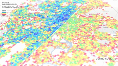
COVID-19 lockdown influences on business diversity in Moscow neighbourhoods
Monitoring mobility
The project explores the changes in population mobility using anonymized and aggregated GPS data, i.e. the decrease in overall mobility and the change of its structure. It introduces a breakthrough concept of dwell-time categories, such as transit, commute, and public space visits vs. shelter in place, that can effectively be converted into revenue expectation ratios.
One can also monitor the landscape of urban centralities (hot-spots) finding: which points of interest continuously attract mobility flows and which ones vanish on the map of human and business activity.
Also, one can connect it to the lockdown policies and environmental conditions, such as pedestrian accessibility of green areas and core commercial and social services, or the size of urban blocks and the dwellings’ insolation, floors and amenities, or pedestrian and bike infrastructure.
This article is part of a series of publications resulting from FIABCI's partnership with Habidatum.
About Habidatum
Habidatum is a software and data analytics company, assisting policymakers and businesses in understanding the hyper-dynamic urban environment through advanced analytics of diverse data sources driven by machine learning and interactive visualization.
Habidatum operates as a gateway between the professional communities that require data-driven insights and data carriers.
The company was founded in 2014 by a collaboration between professional urban planners and digital designers. Since 2014, the company has worked in more than 20 cities globally including London, New York, Moscow, Dubai, Singapore, Pune, Denver, and Miami.


![[Webinar Summary] COVID-19: What lies ahead for the Real Estate Industry?](/uploads/news/9i1w05plq2ksbcswuyj5ze2nr.png)


